

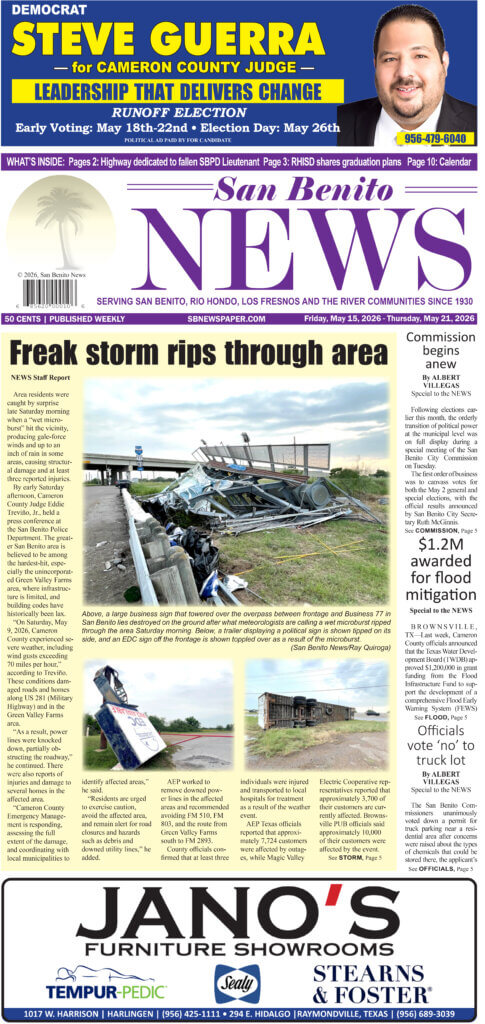
Special to the NEWS
The National Weather Service (NWS) in Brownsville issued a tropical storm watch for the lower Rio Grande Valley area on Thursday morning.
The watch continued as of presstime for Brooks, Kenedy, inland Willacy, inland Cameron, coastal Willacy and coastal Cameron counties not to mention for those with marine interests in the Laguna Madre and Gulf of Mexico waters from the mouth of the Rio Grande north to Baffin Bay.
At 5 a.m., the center of Tropical Storm Don was located about 580 miles east-southeast of Brownsville or about 600 miles east-southeast of Port Mansfield, moving at 40 mph west-northwest.
Last reports indicated that Tropical Storm Don was organizing in the southern Gulf of Mexico and is expected to track toward the Texas coast through the next 24-36 hours. Isolated to scattered showers and some thunderstorms and tropical storm-force winds will accompany Don as it eventually makes landfall in South or Deep South Texas.
The NWS urged those under watch to begin preparing their homes or businesses according to individual hurricane disaster plans. “Listen for possible warnings and be ready to evacuate if necessary. Heed the advice of local officials and comply with any orders that are issued,” read the last NWS report as of presstime. “For interests at ports, docks, and marinas, it is recommended that you perform the prescribed preparations according to your emergency operations plan for tropical cyclones. If you live on a boat, begin to safely secure your craft and make plans to leave it for adequate land based shelter. Listen for possible warnings.”
Regarding the coastal waters under watch, it is recommended that small crafts should return to port or seek safe harbor.
In the meantime, City of San Benito Emergency Management officials will be holding a conference call this morning with NWS representatives. It’ll be decided afterwards whether sandbags will be issued in San Benito.
For additional precautionary and preparedness information, San Benito residents can call city hall at (956) 361-3800 or (956) 361-3804, ext. 306. Citizens of Rio Hondo can call city hall at (956) 748-2102. Check back at www.sbnewspaper.com for official storm information and possible changes to the forecast.
The next local statement was expected to be issued by the NWS around 12 noon.


Recent Comments